A very short trip, but one that requires effort at the end. However the view is worth it! Just don't be blown away by it, literally. :)
Difficulty: Light
Round trip: 4 km
Hiking Time: 2 - 3 hours
Elevation Gain: 350 m
FitBit: approx 7,700 steps and 123 flights of stairs
Location: Kananaskis
TRAIL HEAD
Marked: No
Facilities: No
How to get there: From Calgary drive south on Hwy 2. You have multiple options to go through different small towns such as Black Diamond, Longview, or High River, just choose the way you feel best, and make your way south on Hwy 22 to Hwy 532. Turn right (W) and drive approx 21.5km to where you'll see a small pond. Cross the Texas gate and park in the pullout just after it on your left.
HIKE DETAILS
Your trail starts on the northwest side of the road directly across from where you park. Walk up the little hill and head nw, almost immediately you will see and hear a stream's trickle on your left. You will also see two narrow paths on the slop of the hill, stick to the lower one closest to the water. (If you are too close to the stream and don't see the path, walk up the hill a bit more).
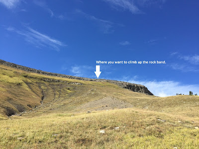
As you hike you'll see your destination butte ahead to the north and there is a fire lookout on top (which isn't really visible). You'll gain elevation at an easy pace in the first km, but the last 0.5km is when the real work begins. When your trail appears to dissipate head to the left of the butte and up the steep and grassy slope, the trail will be intermittent so use your best judgement and just aim for the shortest part of the rock band. (Note: at this point there is a trail that seems more obvious and continues to the right of the cliff/butte, in a sort of gully/dip between cliffs, that is not your path. You want to be on the left rock band, as daunting as it seems, it's doable and where you should be). As you make your way up the slope be cautious not to send rocks tumbling down to hikers below you.
Once you get to the rock band you will have to do some climbing (dogs will have to be lifted), and if you can bring knees to chest, it's just like giant stairs for 3 or 4 steps. From there you still climb, but it eases up.
At the top, enjoy the 360 degree view you earned! Note you may be able to see Calgary on a clear day!
EXTRA TIPS
-Ranked 'light' this one is short in distance, but the elevation gain at the end is steep so it won't feel very easy.
-The wind once you come over the ridge is merciless. No matter how much you might sweat on the way there, it can't hurt to dress in layers, plus bring a touque and mitts.
As you hike you'll see your destination butte ahead to the north and there is a fire lookout on top (which isn't really visible). You'll gain elevation at an easy pace in the first km, but the last 0.5km is when the real work begins. When your trail appears to dissipate head to the left of the butte and up the steep and grassy slope, the trail will be intermittent so use your best judgement and just aim for the shortest part of the rock band. (Note: at this point there is a trail that seems more obvious and continues to the right of the cliff/butte, in a sort of gully/dip between cliffs, that is not your path. You want to be on the left rock band, as daunting as it seems, it's doable and where you should be). As you make your way up the slope be cautious not to send rocks tumbling down to hikers below you.
Once you get to the rock band you will have to do some climbing (dogs will have to be lifted), and if you can bring knees to chest, it's just like giant stairs for 3 or 4 steps. From there you still climb, but it eases up.
At the top, enjoy the 360 degree view you earned! Note you may be able to see Calgary on a clear day!
EXTRA TIPS
-The wind once you come over the ridge is merciless. No matter how much you might sweat on the way there, it can't hurt to dress in layers, plus bring a touque and mitts.
Happy Hiking!
Happy Hiking!


